(RU) Arctic Freshwater Pathways - Russian Team Assesses Global Ocean Reanalyses in the Kara Sea
As part of the PARADIGM intercomparison, the Russian team evaluated the performance of major global ocean reanalyses in the Kara Sea. The results show that while temperature fields are accurate, salinity remains significantly biased due to limitations in river runoff representation.
Within the joint work of the PARADIGM project — Russia (Shirshov Institute of Oceanology, RAS), China (First Institute of Oceanography), Brazil (Rio de Janeiro University), India (Institute for Climate Studies), and South Africa (Institute for Ocean Observation) — we compared ten of the most widely used global ocean reanalyses for the Arctic seas of Russia (each country examined its own region of interest). We showed that sea temperature is reproduced well, whereas salinity exhibits a persistent “salty” bias and underestimates the freshwater discharge from the Ob and Yenisei rivers. The practical conclusion is twofold: first, reducing salinity errors and improving forecasts of ice conditions and ecosystem indicators in numerical models requires moving from climatological river discharge to operational, seasonally varying river runoff data and prescribing them as full-fledged lateral boundary conditions (the simplified approach of treating river discharge as a surface flux is not fully correct). Second, global ocean reanalyses should be used with caution for regional ecosystem studies, keeping in mind substantial errors in reproducing the freshened surface layer in the Arctic shelf seas.
The Kara Sea is a crossroads of the Arctic where sea ice, warm and salty Atlantic waters, and freshwater from the great Siberian rivers — the Ob and Yenisei — all meet. The way these waters mix determines the beginning and end of the ice season, navigation routes, the state of coastal ecosystems, and even how much freshwater flows onward into the Arctic Ocean.
Modern global ocean models, known as reanalyses, combine satellite and shipboard observations with physical equations to reconstruct the daily state of the ocean over many years. They are used by forecasters, ecologists, marine operations specialists, and climate prediction developers. But how well do these products describe the Kara Sea specifically?
A team from the Shirshov Institute of Oceanology, working within the international PARADIGM project (Russia, China, Brazil, India, South Africa), evaluated ten of the most popular reanalyses. We compared model data with satellite maps of surface temperature and salinity, as well as direct measurements collected during decades of Arctic research. The results were striking.
Surface temperature is reproduced by all systems very closely to observations — errors are small, usually less than half a degree. This is expected: temperature observations are widely assimilated into reanalyses and strongly anchor the numerical solution to reality.
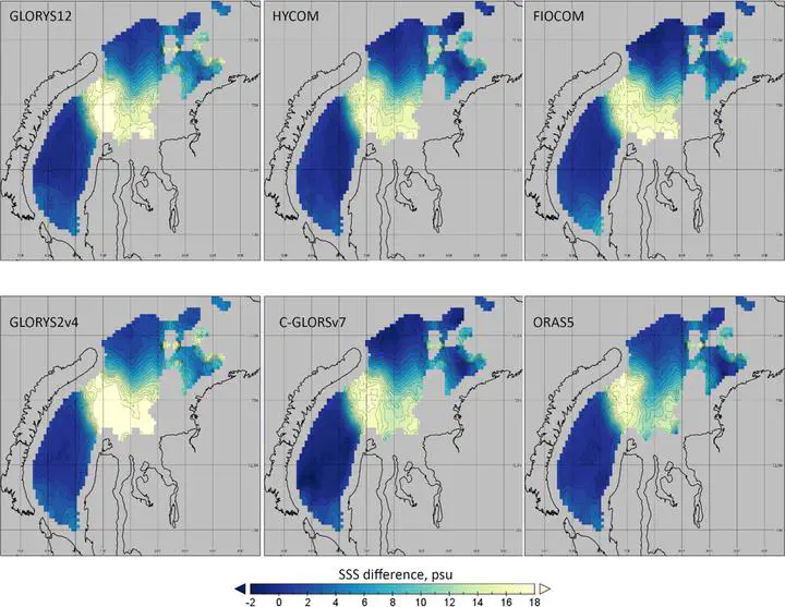
Salinity, however, shows significantly larger discrepancies. All products are too salty where measurements indicate a strong freshwater plume from the Ob and Yenisei. In other words, the models underestimate the extent and reach of the freshened waters from these great Siberian rivers. On maps, this appears as a “salty tongue” extending north and east from the river mouths — in satellite data it is wider and reaches farther into the sea than in the simulations (Figure 1).
Why does this happen? The main reason is how the models prescribe river discharge. In most systems it is taken from “climatology” — multi‑year averages that smooth out natural variability and extreme years. In addition, freshwater is introduced as a surface flux (similar to precipitation), forming a very thin layer that is easily mixed by wind, whereas in reality a 10–20‑meter‑thick freshened layer with its own temperature and salinity forms in the estuaries. As a result, in the models freshwater is diluted too quickly, and the plume becomes shorter and weaker.
What does this mean in practice? First, salinity errors lead to density and stratification errors, which affect the timing of sea‑ice melt and formation. Second, conditions for plankton and fish that depend on a stable freshened surface layer are misrepresented. Finally, estimates of the amount of freshwater from Eurasian shelves entering the Arctic Ocean — a key component of the larger climate system — become distorted. Thus, global ocean reanalyses should be used cautiously for regional ecosystem research, with awareness of substantial errors in representing the freshened surface layer in the Arctic shelf seas.
The good news is that the paths to improvement are clear. We recommend:
- Transitioning to operational, seasonally varying river discharge data (based on gauging stations or global hydrological systems with mandatory calibration) instead of climatological values.
- Prescribing discharge as a lateral inflow with realistic layer thickness and water properties, rather than as “rain” onto the surface.
Such changes are technically feasible in widely used models and should significantly reduce the “salty” bias along the Ob–Yenisei plume. More accurate salinity fields mean more accurate ice forecasts, safer navigation, and more reliable assessments of Arctic ecosystem conditions.
We hope that these results will help developers of global models make the Arctic in their products closer to reality — to the benefit of science, the economy, and everyone working in high latitudes.
The maps in the figure show how much the models “misrepresent” sea-surface salinity compared to satellite observations in the Kara Sea. Light-colored areas indicate where the models are too salty, meaning they underestimate freshwater from the Ob and Yenisei; dark blue areas show where the models, on the contrary, freshen too much. The “salty tongue” extending from the river mouths northward and eastward is clearly visible: this indicates that the models produce a plume that is too short and weak. The smaller this “tongue,” the closer the model is to reality; the wider and paler it is, the larger the error and the poorer the river discharge representation.
Mikhail Krinitskiy
Researcher (Russia)
Current research interests are machine learning, deep learning and AI of various flavours applied in Earth Sciences started with observational applications, now shifted to generic data mining and natural processes modeling. The main applications are in Atmospheric sciences, including remote sensing, and also in Ocean sciences. There are also some applications in geochemistry and paleoreconstruction applications. Lecturing masters courses “Machine learning for Earth Sciences” and “Deep learning for Earth Sciences,” a.k.a. ML4ES and DL4ES (Rus.) in Moscow Institute of Physics and Technology, Lomonosov Moscow State University and HSE University.